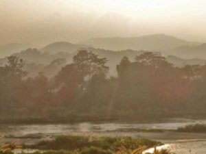
MapBiomas uses maps to tell the history of evolving land use and its impacts.
Tasso Azevedo of MapBiomas spoke with Skyler Reid on February 22, 2023. Click here to read the full conversation with insights highlighted.
Skyler Reid: Could you please introduce yourself and describe the problem that your organization, that your work addresses?
Tasso Azevedo: I am Tasso Acevedo, general coordinator of MapBiomas, and also [working] on a new initiative to bring connection to the internet to forest people and communities in Brazil. We have a problem which is, most of the greenhouse gas emissions on the planet comes from the burning of fossil fuels. But in the case of Brazil and other tropical countries, it’s the opposite. The main source of greenhouse gas is land use – deforestation, pasture land, livestock, agriculture, fertilizers, and so on. We are trying to understand what’s going on in land use and then, through that, be able to promote uses of the land that result in conservation of natural resources and reducing greenhouse gas emissions, and, at the same time, adapt ourselves to climate change. MapBiomas does this by understanding what’s going on with land use, and then being able to interfere and inform the decision makers in this field to take the better actions and decisions, based on the information that we sent.
In the past, we would say our mission was to make the maps and produce the information. But as a network today, our mission is to be sure that every tropical country will have the local capacity to develop the studies and the maps to cover land use. That they have the full capacity to reproduce this model.
Skyler Reid: What does that look like just in action? What does that look like in a direct day to day?
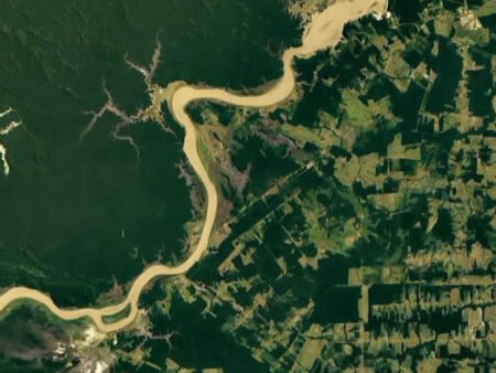
Tasso Azevedo: We have a main product that we implement, which is mapping of land cover and land use, yearly maps, and historical maps, that we produce in any country. We start in ’85 and we produce maps of each year. Those maps reflect much more than corporate loss and corporate gain, for example. It actually shows all the transformations you have on the land.
If it’s, for example, a forest and becomes pasture land, and then after it becomes an urban area, or something like this, you have the whole history. We have different topics that we map, so it’s always wall to wall maps. For example, the map of Brazil has 27 classes. We map 27 different land cover and land use for all of the country in a very fine resolution, it is 30 meter resolution. Every square 30 by 30 meters is mapped. You have the history because you can tell the history of each pixel, you can tell the history of all the landscape. In any part of the country, you can see the transformations, from one very basic application. It’s happening today. We have had these big rains and floods now in Brazil. There are six municipalities that are impacted and we are just now producing a time lapse showing how the land cover, the land use has changed in the last 35 years – and how this is linked to the areas that were more fragile and impacted by the rains. There was deforestation at the top of the mountains.
Revitalizing those sites where we have the problems today, we can actually predict where the next areas to be destroyed could be. We don’t do the application ourselves, but we produce the basic information that will be used for everyone that is doing applications. We also produce specific maps, for example, maps for mining, maps for tracking irrigation areas, we also track water surface on a monthly basis because there are a lot of variations during the year. We track fire scars every month, also, since ’85, always with this fine resolution. For each 8.6 billion pixels that we have in Brazil, of 30 by 30 meters, you have the history of all these types of information and you can combine this history to understand what’s going on, and what action you should do.
There is a separate initiative called MapBiomas Alert, which is dedicated to investigating every single deforestation that happens in the country. Any sign of deforestation, we evaluate one by one, and we produce a report for each [case of] deforestation. Brazil is now the only country where every single deforestation [instance] has this specific report. We produce about 2000 reports per week, and these reports can be used by banks for finance decisions or by the supply chain to decide whether products are coming from deforestation or not. They can be used by enforcement agencies to create actions and things like that.Today there are 14 countries making these maps, but our model now is to multiply the number of countries that are able to produce this, because this is very powerful if it’s done locally because the people will be mapping what matters to them.
What we map in Brazil is totally different from what is mapped in Indonesia because, for example, for them it’s very important to map palm oil. In Brazil, palm oil is not a big thing, so we don’t map palm oil but instead we map sugar cane or soybean. That is not important for [Indonesia]. This idea is that you don’t make a global map, because if you make a global map, we have something that has no utility for local [communities].
The idea is, if you have the capacity to do those maps you’ll be able to actually develop mapping of what is necessary, what is a priority for your region, what can be more influential. It’s always a network, it’s always a blend of different organizations with different capacities working on each country to develop those products.
Skyler Reid: Who uses the service directly, and then who benefits?
Tasso Azevedo: There are several users. Actually, last year, 300,000 people were digging into the data. It’s a lot of people from different sites, but I would say that we characterize them in different groups. There is the group of journalists and people in communications who want to use the data to explain things that are happening. We’ll do a time lapse of the changes for the main news on TV so they can communicate what’s going on. Then we have the people in the government and enforcement agencies so they can track many things in terms of regulations, if it’s legal, illegal, deforestation, degradation. They can also see if irrigation is happening, or where it’s authorized or not, and things like that. These are regulatory agencies, and public prosecutors, also, they’re involved. Then we have the industry, which wants to know how the land is being managed from where they are buying their products, for example. There is also the agro industry that is interested, for example, in understanding the water surface variations and whether they will have the kind of conditions for planting. And if they want to avoid deforestation, they can see on the maps. There are several users from the banking side. For example, the largest bank doing credit for agriculture, which every year puts out $40 billion in credits. Every single loan that they give, they check in our system [to see] if there is deforestation or not. Then there are people in science doing different studies on biodiversity, health issues, and they use this type of information, for example, to define areas that are endangered, for endangered species, and things like this. The managers of protected areas, they use to create the management plans for protected areas because the maps are ready to go. There are several applications.
We promote this application with a prize each year. It’s called MapBioma’s Award where we receive projects and applications that have been done for different people in the public sector and private sector on combating deforestation. There are several categories. In the last few months, we have about 15 to 20 peer reviewed papers published every week using data from MapBiomas. Everything we produce is an open data source and is free for anyone to use, including all the codes. All the source codes of how we process the data, et cetera, it’s all open so anyone can try to process it themselves. It’s all done on the cloud, so it’s possible for anyone to reproduce because you don’t need an infrastructure and so on. The model is based on that so it can be democratized easily. You don’t need an infrastructure, you just need to have smart people with a lot of fire to push in this.
Skyler Reid: What makes your approach distinctive or unique among other types of similar services? Is there something distinct about how you are approaching it?
Tasso Azevedo: As I said, there are different initiatives doing global mapping and I think we do three things differently. One, we don’t want to have only maps; we want to have the local capacity to produce them. People at each local, they understand what the things are that they have to map, why, and to pursue the right thing to do. We don’t have to agree on a specific legend. They can do it by themselves and prioritize [their needs]. That’s the first thing. It’s all about creating capacity locally to create maps that matter for the people that are on the ground.
The second thing is that we focus on land use and land use change, not only deforestation or reforestation. We piloted this in 2015 and I think it’s still the most complete and long work on this. The third one is that everything is open, including all the source codes. This is very important because a lot of these global initiatives, you can’t reproduce or you don’t have the computer capacity available that was used, or you don’t have access to the codes, et cetera. I think these are the three things that distinguish MapBiomas from other initiatives. And it’s a network. That’s another thing that’s important, four pillars. It’s a network, it’s not like an institution. In Brazil, it’s about 35 institutions. Globally, all the fortune countries, it’s now 70 institutions from academia, from universities, from NGOs, tech startups all working in a collaborative manner in their spaces.
Skyler Reid: Are there any specific examples that really illustrate the impact?
Tasso Azevedo: There are many. For example, you have the financial sector where, before giving any loan for agriculture, they check whether there is deforestation going on. We had tons of deforestation alerts before. In 2018, for example, there were 150,000 deforestation alerts in Brazil, and less than 1% were taken action on. Before there were just 1000 reports done for the entire government and now, we publish 2000 reports per week, so it’s really pushing different organizations to [take action]. Last year we completed 10,000 actions. So it went from 1000 actions in 2018 to now, we are at 10,000 actions and hope to finish this year with 50,000 actions.
It’s pushing this to another level in terms of, “Okay, if you do something wrong in the forest, first you’ll be caught and second, you’ll be reported. Third, there will be a consequence.” This piece of the consequence we need to increase very fast. The report is online; everyone can see the report and everybody can push the government to say, “Well, why don’t you act? You have the report there, it’s publicly available. Why don’t you act?”
For water, it was very important for the debate, especially on the question of irrigation because irrigation is growing very fast in Brazil. Although it’s only 12 to 14% of the agricultural area that is irrigated, it’s consuming 70% of the freshwater. If you double irrigation, which is the plan for 2030, then you would be consuming much more water than is available today. These are things that are helping the different organizations that work on this regulation to think through how to coordinate this better.
There are other ones. There is a group that is studying yellow fever and you need a monkey to be the indicator of yellow fever. When monkeys die, you check the monkey, you see if they have yellow fever, and if they have yellow fever, you start to vaccinate people nearby. The problem is, in many places you don’t have monkeys anymore. You have to rely on the closest forest that has monkeys and if that monkey gets infected, maybe you should be vaccinating people 200 kilometers away, because that’s the last indicator. They use our maps to actually find out where there are viable populations of monkeys that would be able to serve as an indicator and, based on that, they create maps of reaction. So, these are applications that we didn’t think about when we were starting the project, but there are several of them linked to this kind of use.
There’s another interesting one, we map all the gold mining in Brazil. The mining is divided [between] industrial mining and artisanal mining. Brazil is one of the largest mining countries in the world. We had no idea that the area is occupied by tons of small [artisanal mines]. It’s larger than the area of the big mines. The second thing we learned is that the miners inside indigenous lands increased six times in the last decade. We could track the [water] contamination that was happening in Santarem, which is very close to the Amazon River, [and see that it] was coming from gold mine sites 600 kilometers away. We could track this on the water, showing how the residuals from that place are going to that city. We tracked all the airstrips all over Brazil and we found out in the Amazon, [there are] 2,800 airstrips. and the official number in Brazil was 1,200. By finding those places, you can find out how illegal mining is actually spreading, so the government can now start to destroy all those strips that aren’t authorized.
The idea is that we want to have this across the tropics. Groups of people that are able to produce basic maps, but also to react quickly and give answers to other things that people need.
Skyler Reid: What are some of the insights and teachable lessons that can be taken from your work that others could use?
Tasso Azevedo: To create a massive impact at the local level, but at a large scale. There’s no better model that works on a network. It’s not like the work of one organization or one hero. Spreading this out and having many people with the capacity to do it is a wonderful thing to do.
This is my third project building up networks to solve complex problems and I think this is really the way to go. You can move fast. You always have people that are creating different solutions. You also have people who fail very quickly, so we learn very quickly. Like, you fail at something and everybody learns at the same time, and moves to the next one. It’s very efficient, and in fact, you progress very quickly. For complex tasks, or tasks that need a lot of people, a network will help. Having more people thinking about the problem will help.
The second thing is, it’s counterintuitive and a little bit technical but it’s important, it’s much easier to have a time series of 35 years of good maps, than to have one good map for one year. The reason for that is because when you are doing time series, you can use three dimensions to think about a problem. You can use the spectral dimension; you can use the space dimension. But you can also use a time dimension and the time dimension helps us to understand what’s going on each year. If you add in a dimension, it helps us get better results, even if it looks like more work to do.
The third one is all about open source. I truly believe that by making everything that we do totally open to anyone to check or to do by themselves, to copy what we are doing, it’s probably the easiest way to progress faster, in terms of our end goal. We have been working on this for the last seven years and always hear, “You have to find a business model to pay for this”. And I keep saying, “That’s not what we need.” It’s not a question of finding a way to have a business model where people can pay. We just have to have that as a global common to everyone, and keep finding resources to continue this every year. Not as a service, but as a source of knowledge for many others that can do the source. Even for for-profit organizations, it’s free and open. We just want everyone to make good decisions.
Skyler Reid: How have you measured the success of this project?
Tasso Azevedo: We developed what we call impact assessment. It’s not us that is doing the impact, the impact is done by the users of the data. I don’t feel comfortable actually crediting ourselves for the results that are being done by other people. But since people want to hear something like this, we are doing the exercise of creating these impact assessments. But I think the impact of controlling deforestation is done by the agencies that are controlling it. We are giving a small contribution, giving the maps, and so on. There will be an external evaluation going on and we will suggest a series of indicators and processes to evaluate the impact. But as I say, we would call it impact much more for the stories, as in telling the stories, than from any kind of specific measure, like how many people impacted.
Skyler Reid: Every social innovator learns as much from the things that don’t work as the things that do. Are there things that you’ve tried while working on this project, that you’ve learned because they didn’t work?
Tasso Azevedo: Every day there’s something going wrong. There’s no such thing as an easy way to go. One thing I learned early is that I truly don’t believe in strategic planning. I think if you spend too much time doing the planning, the result is that you don’t want to change the plan because you would take this much time again. I usually don’t do any of this, I just do big visions, where we want to go and what would be the strategy in general terms. Then, set up milestones to achieve in terms of results. Because if you spend too much time on perfect planning you will go nowhere.
As a result of that, when we work with the funders and the partners, we don’t want anyone that wants to earmark anything. That doesn’t help us, it actually creates problems. Whoever is supporting us is supporting the whole thing, even if it’s a hundred dollars, it doesn’t matter. You are supporting the whole thing. Even if you maybe lose someone in the middle because they don’t like this method, I think it’s worth sticking with this idea that we should move with everybody as part of the entire project, instead of being too picky.
Skyler Reid: Aside from the very normal things like where do you find funding, are there challenges that you’ve faced or that you’re facing, that you’ve either not been able to overcome, or things that haven’t really been solved to the most satisfaction?
Tasso Azevedo: Every day we have some things that are not working. It’s every day, every hour. I think that’s part of life. I look at the problem and try to find out, if there is a solution, there’s a solution. If there is no solution, let’s move on. For example, the thing that has been a frustration until now, is that we were not able to get into Africa because we couldn’t find the right partners.We need to find local [partners]. We find partners internationally; but we’re not finding the local partners that we want to find. On Saturday, I’m traveling to the Congo Basin to spend some days there, and talk with different people to see if we can find those partners. I think this is our main frustration at this point.
Skyler Reid: Just to follow up on that a tiny bit, looking at that as a specific example, how do you go about trying to find local partners?
Tasso Azevedo: It’s basically talking with different people, getting different indications, then starting to talk with them. We have to find organizations that want to lead a process. We don’t need organizations that think that they can solve everything by themselves because they will not be building networks with local capacity. They’ll be building just a super organization to do it. That’s one thing. The second thing is that they are committed to good science. They don’t need to be specialists on anything we do but it’s just having this attitude of trying to do the things with the best science possible, or science-based, if they are not scientists. Also, people that are totally fine to build things are totally open. You build something, it’s open, it’s out there. Everything you produce is out there for everyone. I think these three practices are very important.
Skyler Reid: Are there any kind of system level changes that you’re working on in the overall field? Things that you’re hoping are implemented by other people working in the same field?
Tasso Azevedo: I think it’s probably everything that I described. Change the scale. If you’re doing 1,000 actions, how can you move for 50,000 actions? Multiply by 50. Try to find out where we can help them to make this move and what sorts of things could we do to have this mentality to scale up things. If you work on a network, it helps to progress faster. Everything we do, we do easily 10 times faster than any public agency. Although, they would have more capacity, more funding, et cetera. It’s such a different approach of doing things openly, in a network, cooperating all the time, and stuff like that.
Skyler Reid: How do you see your work evolving over the next five years?
Tasso Azevedo: By 2030, we want to have this local capacity in most of the tropical countries. At least, all of the tropical countries that want to have it. We have all of South America now, and we want to get into the main countries in Africa, and also Southeast Asia. This will be the main goal as a network. As for Brazil, we want to be sure that Brazil, by 2030, is net-sink from the land use setup. That would mean they have very low deforestation, a lot of reforestation, restoration, soil regeneration, good agricultural practices, market [inaudible]. In the end, if you look at the numbers, we want to have a decrease in our emissions, but a decrease to compensate for emissions from other sectors. The goal is to have the capacity to do the things that we are doing in Brazil in all tropical countries, or at least a majority of them.
Skyler Reid: As those networks build, as it’s expanded into more locations effectively, how does that evolve the work that you are then doing? Is there anything that you feel like will be changing or will it just be continuing to support these different partners?
Tasso Azevedo: I think it’s about scaling up. Today, Brazil plays a very specific role in expanding the network, but if we have the whole cycle with every partner in every country in the network, then those countries will also be multipliers. The whole cycle is, you learn how to do it, you produce a network, you learn how to do the maps, and how to develop new techniques and maps properly, and then you can reproduce the network. You could have Indonesia helping to have the system in Malaysia or Thailand, or in Papua New Guinea.
This multiplication effect, just as a network, is what I mean. I’m not saying what’s the specific goal for each country. Because each country will have their specific goal. So in the case of Brazil, my goal is to have the land use sector as a net sink of carbon.
Skyler Reid: Is there anything that we haven’t covered, or that you would like to add, that you think is important?
Tasso Azevedo: Thinking of the forum, I will be also showing and working on another initiative MapBiomas has helped to set up, which is this project to connect to the internet, every single indigenous person and other forest communities in the Amazon. We are talking about 5,000 communities to connect to the internet and have digital inclusion. To help them to protect their territory, access education, access telemedicine, economic inclusion, and so on. It’s a massive kind of infrastructure project, in a way. It’s something on the scale of, I don’t know, a hundred million dollars, because you have to bring energy together with the internet to make this happen. We’re investing a lot of time on this project now because I think it’ll be very instrumental in the way we protect Amazon. We know through MapBiomas that the most protected areas in the Amazon are not the national parks or biological reserves, but it’s actually the indigenous lands. It’s the land that is occupied by people that depend on forests that are the most protected areas. But they’re also the most threatened areas right now. So, to empower the communities is to empower our capacity to protect the forest and maintain the lumber. I will be going around to learn as much as possible of what people are doing in this field.
We are moving fast. We had one community out of 5,000 with fast internet, about a hundred megabytes up. By the end of March, there will be 60. And by the end of this year, if everything goes well, we’ll have 800 connections. And we want to have all the 5,000 connected by 2025. It’s pushing very hard, there is no pilot, it’s very small. It’s just transforming all of them at once.
Click here to read the full conversation with insights highlighted.
Skyler Reid is a multimedia producer and journalist living in New York City. He’s worked on award-winning projects both nationally and internationally, and has produced photo, video and text features for publications including The Washington Post, The Guardian, VICE, NBC News and others. He’s covered breaking news and features for wire services including Reuters, the Associated Press and Agence France-Presse. Much of his work focuses on urban development and communities, but occasionally delves into Satanic crime, pot churches, and pro wrestling. He takes too many photos of his dog, Bowie, and is obsessed with karaoke.
* This interview has been edited and condensed.
Find other social change organizations focused on land use.