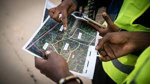
Humanitarian OpenStreetMap develops open source apps and tools for collaborative mapping and geospatial data collection. The organization uses map data for disaster management and to contribute to achieving the Sustainable Development Goals.
Liz Chamberlain of Humanitarian OpenStreetMap spoke with Ambika Samarthya-Howard on November 3, 2023. Click here to read the full conversation with insights highlighted.
Ambika Samarthya-Howard: Can you introduce yourself and your organization?
Liz Chamberlain: Hi, I’m Liz Chamberlain. I work for Humanitarian OpenStreetMap team. We have an office in the US, but we have four regional hubs all around the world. One in Asia Pacific, one in Eastern and Southern Africa, one in West and Northern Africa, and one in Latin America and the Caribbean.
Our priority regions are what a lot of people are calling the global south. We also have a global team that’s scattered around the world, that supports the hub’s implementation work.
Ambika Samarthya-Howard: Are you based in the OpenGovHub in the States?
Liz Chamberlain: We are.
Ambika Samarthya-Howard: Can you talk a little bit about the purpose of the organization and its approach?
Liz Chamberlain: We believe that a missing match [between a geographical location and a map] should not be cause for human suffering, but in fact, there’s a market failure in the world around maps. Google, or Amazon, or Meta, or other groups don’t necessarily have a business interest in mapping all of the world. They have an interest in mapping parts of the world.
The parts that are unmapped by the private sector are often left off the map, so when there’s an emergency, or just a need in those communities, or those locations, there’s not always a way to reach them or to understand exactly what’s going on.
That’s essentially the problem, and that’s where we come in. We are a nonprofit organization, but we’re also a community. We think of ourselves as a global community, and our team engages the global community in a lot of different ways to contribute to the map.
We have a global volunteer network that’s based all over the world, where people can contribute to the map, edit the map, and add things to the map. Our team also works with communities, local organizations, and local groups on the ground to solve the problems that they need to solve.
Our organization has these four regional hubs, so we are as close as possible to the work happening on the ground. We also have a tech and data team that builds products that make remote mapping more accessible to people on the ground. It’s all open source. We work on the platform OpenStreetMap, and we use other open mapping and open data tools. It essentially becomes a public good once it’s put out there.
The idea is to create participatory mapping and public goods, and our team builds tools and facilitates that process for communities and partners all over the world.
Ambika Samarthya-Howard: Can you give me an example of one of these communities and how it’s shown impact? And then, having been around for several years, does your team think this work will be finite because the world doesn’t scale?
Liz Chamberlain: In theory it would be finite, but things are always changing. For one, it’s still a lot of work. We’ve estimated, and our goal is to map an area home to a billion people. People talk about this as “the bottom billion,” but [they mean] people in the most vulnerable areas. And it’s harder to map these places because they’re in very remote areas, or they’re informal settlements that are just really difficult to map. And again, the business interest isn’t there.
So we have the goal to map a billion people, but it doesn’t end at mapping homes and buildings. What we then want is to use all of the data on the map, and the more significant, deeper level data, to help people solve problems. Mapping all the buildings and roads is just one step of many. Then it’s adding more information to the map and using that data.
As an organization, we have this one billion goal, but we know that there’s work beyond that. And we’re already doing it.
Ambika Samarthya-Howard: Do some cases have to do with roads and road safety?
Liz Chamberlain: Roads are immensely important for healthcare and disaster response. If a road or a bridge is broken, or if a road has collapsed [that needs to be reflected on the map. Road access] changes all the time, so it’s really important to update the map constantly.
Mapping data can be used for an almost infinite number of problems around the world, which is exciting. But we’ve kind of narrowed ours down to five impact areas, just to provide some focus. Those are related to the SDGs [Sustainable Development Goals]. We have disasters and climate action, sustainable cities and communities, public health, gender equity, and safe migration.
Within that, we have a number of different examples. For instance, within climate and sustainable cities, we’re looking at a lot of sea level rise. Nakuru, Kenya is a quickly growing city on Lake Nakuru, and Lake Nakuru itself is rising. I don’t know all the causes of that, but the sense is that it’s climate related.
Our team worked with a team on the ground and the local government to understand where that was going to affect communities or existing development, and also to help with the planning of future development. There’s this idea of creating a “sponge city,” where you build and create structures that help the water be absorbed back, so the city doesn’t flood regularly. That’s one very specific use case. Another one is mapping water points.
This is something that we know organizations are doing. I’ve actually done it in a prior job, but it can be very time-consuming to map water points. If you’re using satellite imagery, you can hone in on where they are, and the mapping that we do can really speed things along.
The [water-mapping] data I developed was used by the local government to put in new water points. Some really interesting findings emerged that showed most of the working [water points] were in certain regions or parts of the landscape, and the non-working ones were in other places. I can keep going on and on, but we’ve done a lot with disaster preparedness in Southeast Asia and the Philippines, working with their local governments to come up with evacuation routes and mapping where typhoons and other disasters are most likely to strike.
The organization that works with CHWs [Community Health Workers] is helping them identify where they need to put CHWs and where their focus areas should be. I don’t want to say the examples are endless, but there are dozens of them.
Ambika Samarthya-Howard: How do you figure out and track your success?
Liz Chamberlain: We have a number of key performance indicators, and some of them are very basic, like the number of buildings we’re mapping, the number of people involved, all of that. Then we track use cases. We are actually in the middle of an evaluation process with an external consultant to help us understand the longer-term impact of each of these use cases and situations.
We get feedback from communities and partners who say, this was really helpful. But we are still trying to figure out exactly what that means and how long term that effect really is.
Ambika Samarthya-Howard: I think that’s the hardest part. I feel like anecdotally, or when you’re doing the work in the space, you have a sense of things. Then, when you actually put it down on paper to track it and make it causational, it’s very hard.
Liz Chamberlain: Yes, attribution versus contribution is challenging. We know that we’re not the only players in these solutions. We don’t do things without community involvement and partner involvement, so we aren’t the full solution. That’s not the point of it. Everything we do is to accelerate and make more efficient the other work that people are already doing, the problems that they’re solving.
In some ways we don’t want to have full attribution because we want others to own it going forward.
Ambika Samarthya-Howard: What are some lessons you’ve learned from this work? Everybody laughs when I ask them that question because there are so many.
Liz Chamberlain: I think on the positive side, we’ve really seen the power of collaboration. I know that sounds cheesy, but it’s the way that HOT [Humanitarian OpenStreetMap Team] started. It was a group of open-source enthusiasts who saw this need for more map data, and it was very volunteer-oriented. Everybody was in it, contributing together. I think that’s really a powerful way to start an organization because it means that we prioritize having people engage with our work.
The whole point is to make it accessible to people, so as more and more people are accessing it, it gets more and more attention.
I often say we don’t really have any competitors, but there are other groups doing this, and that’s great, because the end point for us is to complete the map and make the map really useful. Anytime we work with partners or communities, there’s this power of collaboration; it’s better together. That’s one of the lessons.
Ambika Samarthya-Howard: That’s a really good insight. What about things that you’ve done that haven’t worked? What lessons have you learned there?
Liz Chamberlain: We went through a really rapid pace of growth in the last few years, and I would say one of the biggest lessons learned was putting the strategy at the heart of everything that we do. We grew so quickly, and we hired so many people in a short period of time during the pandemic, and no one could meet each other in person. It was really challenging. Growth is challenging in and of itself.
Having the strategy at the heart of what you do is so important. At times, we were focused more on the systems and the backbones of the organization rather than keeping everybody on the same path toward the vision. The difficulty in that for our organization was that you can use data, and you can use open source software and all these tools, in so many different ways.
As you bring people into the organization who come from different backgrounds, they bring different ideas. The vision can get convoluted when you have so many voices.
Because we have community members involved, we have something called a voting membership that’s made up of these amazing community members all over the world, who also have a say in what we do. And of course, we have a board. We want to make sure we’re listening to the communities themselves, but again, when you have so many voices, it can get convoluted.
I think the flip side of that collaboration that I was talking about earlier is that you still have to have that North Star that everybody is working towards.
Ambika Samarthya-Howard: What are some of the limitations of the model that the organization is working on?
Liz Chamberlain: There are a few. Some are related to scope. We’re working across 94 countries, and language is a really difficult one, because our tools are all in English. A lot of people speak English, but obviously not everyone. And that’s really limiting.
Making all of our tools and resources available in other languages has been something we’re working on. Ideally, you would have tools available in however many languages are represented, but when you’re working in 94 countries, that’s nearly impossible to do.
We’ve put a lot of effort towards translating some of our resources, but we still have a way to go on that. Another challenge is just the scope of 94 countries in general, as you can’t go deep in every single country, at least, not with the size limitations of our organization.
Ambika Samarthya-Howard: How big is your organization?
Liz Chamberlain: We have one hundred people. I guess you could put one person in each country, but obviously, there are other [considerations] involved. We’re often struggling with this question of do we go deep, or do we go broad. We know our mandate is to go broad, but we also know that it’s really important to go deep, especially in instances where there’s demand for this information and people are using the data effectively. Because data that’s not being used is not really worth anything.
Another limitation is a little more technical. We build tech products to help with mapping, and of course the question becomes: Can’t AI just do all the mapping for you? The answer right now is no. We’ve been working with other organizations that help provide AI-assisted mapping. We’re also developing a tool to do this, because we’ve found that AI models are trained on maps and building footprints, for example, in the US and Europe.
That is not really applicable in other places. So if you’re training a model on existing buildings, and you take it to a new place, where the building structures are different, then the AI is not as effective. Our team is launching one tool that essentially trains an AI model on a more local basis.
Ambika Samarthya-Howard: Where is that being based out of?
Liz Chamberlain: Well, our main engineer is based in Germany, but he’s from one of our priority countries.
Ambika Samarthya-Howard: Yeah, it’s just good to be based in a place where there’s a lot of that action and conversation happening. I feel like the progress in machine learning is very much enclaved around the US and Europe, and there are some tech hubs in India as well. It feels like there’s all this very, very, very fast innovation that then needs to be tested.
Liz Chamberlain: Yes. Our team is so global, but whenever we’re doing testing, we do it in the countries where we’re working. When he and his team are developing a product, it’s tested in the priority regions where we work, not in Germany, because then it wouldn’t work. So we have communities, or people in those countries that are helping to train the model. Then it gets better and better the more and more you do it.
Ambika Samarthya-Howard: Do you see yourself as a systems-level organizer?
Liz Chamberlain: I don’t think we started out as that necessarily, but I think now, absolutely because the work we do is at scale, and we do have a seat at the table with UN organizations, the World Bank, and large NGOs. Through different relationships, they’ve seen the value of the data.
Ambika Samarthya-Howard: Once they’ve seen the value of the data, what is it that you need, or would like, from them?
Liz Chamberlain: Really, [I’d like to see] dedication to using data to make decisions. I went to the SDG Digital Forum a few weeks ago. First of all, we’re very behind on SDGs in the world, but everyone was talking about how data can help solve the gaps.
We were actually recognized there as a game-changing digital solution, which was exciting. But I think the point is that it can’t just be one player. We’re beyond that. By getting governments, getting partners, getting communities, and by virtue of touching all of these groups, there is going to be systems-level change [regarding] the use of the data.
Convincing governments to use open data can be a bit of a challenge. They have reasons to use proprietary data, and there’s less visibility in that, so a lot of governments tend to be a bit uneasy about using open data. But we find that when we work with them, they see the value in it.
The partners generally say, yes, of course we want to use open data. But then [the challenge is getting them to], actually use that data to make decisions, and drive up the demand for the data. [Our goal is that] you use it once and then you say, “Okay, this is here. We know this is available.” And then continue to use it because the data is really good.
Ambika Samarthya-Howard: You were talking about breadth versus depth. Over the next five years, are you trying to reach that goal of breadth, or also a few areas of depth, like with the impact pillars you were talking about?
Liz Chamberlain: Our goal is to map an area home to one billion people, working with one million contributors. We’re pretty far along in that goal. We’re around 70% of the way there to map an area home to one billion. I have a feeling that there will be more than a billion to map by that point, because the population keeps growing. So I don’t think that will be finished in the next few years necessarily.
Our pivot now is really to use data, to get data used more and more often. We don’t just want to create the data for no use, but to ensure that it is being used in as many places as possible.
One of our big areas of focus right now is climate. We’re not losing public health or gender equity. Those are obviously really important. It’s essentially this idea that women and other vulnerable groups like children, or the elderly, are more impacted by climate change. Public health, of course, has worsened when there are climate-induced problems.
It’s all not folding in on itself, but I think in some ways, we’re seeing this focus on climate as a central piece of what we do. [A piece] that can spread and continue to include these other areas.
Ambika Samarthya-Howard: What does spending more time on climate look like for you, implementation-wise and in terms of how you share data with governments?
Liz Chamberlain: Yeah, we have a few programs that are climate-focused. One is mapping for climate-ready cities. It’s essentially identifying cities based on a number of criteria, with vulnerability being one of the major ones. In the end, the interest is using the data and working with those cities to map informal settlements or sometimes, in secondary cities, to map the entire city and identify the areas of highest climate risk. We then use that information to participate in the conversation with the government there—the local government, the national government, and partners.
It’s really interesting. We’ve been thinking a lot about how there are these really great high-level hazard and risk models out there, how this data exists, but it doesn’t have local knowledge attached to it. It wasn’t built using participatory processes.
It was done by some modeling, which is great. Those brilliant people need to keep doing that. But at the same time, local communities aren’t aware of that data. So we’re trying to work with local communities, get the information about what is happening to them now, and help make them aware of those longer-term risks. [It could be that] your town might be underwater in 10 years. Whatever the situation is, it’s really unfortunate. Then we bring that local data back into these models as well, so they become richer, deeper models.
Then, we can bring that full spectrum of data to the government and say, “Okay, the community information, the community knowledge is here. Their voices are represented, and these are the solutions that they proposed, or they need a solution,” depending on what each area needs.
Ambika Samarthya-Howard: That’s a really nice loop, and it makes a lot of sense. Is there anything else you’d like to share, any other insights?
Liz Chamberlain: Yes. Going public, I think we would encourage people to consider thinking about not us necessarily, but open data, and using it in decision-making. It’s easier to get than you may realize. I’ve been talking to a lot of people over the last few days, and they’ve talked about their painstaking processes for collecting information on the ground. There’s a lot that open maps and open data can support and make more efficient and more productive. Hopefully, it could make them more impactful in the services that they’re providing.
OpenStreetMap is an open-source mapping platform. To give you some context, sometimes we refer to it as the Wikipedia of maps. Anybody can contribute, but also, if there’s an error, somebody would likely flag it. The quality is really good. We use that in a lot of our tools, and we use other open tools as well, but that really is the heart and soul of what we use right now in our products.
Ambika Samarthya-Howard: What is the work like between your teams and the communities? Do the teams mobilize the communities to get this out there?
Liz Chamberlain: Yes. There’s training involved, and there are grants at some points along the way. But yes, a lot of the communities actually do the registration. Census data is huge. We’ve worked with statistics agencies in several cases. It seems so basic, but it’s actually not that simple to solve. With some of these tools, you can do it much, much more easily.
Ambika Samarthya-Howard: Do you know where the other 30% are? You said you’ve mapped about 70% of the one billion. How do you figure out the gaps?
Liz Chamberlain: It’s the hardest 30%, and it’s the 80/20 rule. A lot of what we do is based on need and demand. So we often address issues other groups are identifying. Partners like the World Bank might come and say, “Look, we want to put electricity into this area, but we don’t know where to put it because we don’t have a map.” If that is brought to our attention, then we can support it.
Incidents like the Morocco earthquake [might bring a need to our attention.] Of course, Marrakesh is very well mapped, but there was no mapping of the rural villages that were very highly affected. The map was just empty in those places, but there were houses and homes and people living there.
Sometimes it’s circumstantial, and these things happen, but we would like to be on top of it. When something missing is brought to our attention, we work with communities and governments, and the more we do this, the more gaps will become apparent.
Ambika Samarthya-Howard: Do you know where the plan is for the next 30%?
Liz Chamberlain: It’s very demand-driven. There’s a lot of India that’s not mapped, so we could go in and map all of India. One of the reasons we’re doing that is climate. In the city mapping project, we’ve identified cities where there’s a lot of unmapped territory. We know the population, and we know what’s mapped, and a lot of these cities are only 30% or 50% mapped. Some cities are only 10% mapped.
We can get that information quite quickly, and see what’s mapped and what’s not mapped, and then know how much we have to fill in. So the thing about that last 20% to 30% is that often, it’s not a huge swath of people. It’s not like one country is unmapped and we can map all of that country.
It’s just pockets here and there. The approach is that when you look at city level, you can look at community level, and you can see those gaps. Those might be brought to us, but we’ll also identify some of them through our programs.
We also know some rural areas that are unmapped and informal settlements that are unmapped. But we’re not going to map them without a use for the data at this point. Maybe some basic mapping would happen, but nothing extensive.
Ambika Samarthya-Howard: That makes a lot of sense if your ultimate goal is to make sure the data is being used. If you get to your one billion, that’s great, but you also want to address immediate needs and immediate demands.
Liz Chamberlain: Exactly. The thing is, once we reach one billion, there’s also other information we can collect that can be mapped. So you could say, yes, we mapped a building, but then you could look at the building material because different materials will withstand different disasters better than others. You can look at elevation because it tells you if it’s going to be flooded or prone to high wind. Once you just do the basic mapping, you can look at that deeper-level data. And that’s the hope, that’s the goal.
Ambika Samarthya-Howard: Thank you so much for taking the time to talk today.
Click here to read the full conversation with insights highlighted.
Ambika Samarthya-Howard (she/her) is the Solution Journalism Network’s Chief Innovation Officer: She leads on innovation and technology, leverages communication platforms for the network strategy and creates cool content. She has an MFA from Columbia’s Film School and has been creating, teaching and writing at the intersection of storytelling and social good for two decades. She has produced content for Current TV, UNICEF, Havas, Praekelt.org, UNICEF, UNFPA, Save the Children, FCDO, Global Integrity and Prism.
* This interview has been edited and condensed.
Find more organizations working to help achieve the Sustainable Development Goals.